Reference code
GemA Flirsch B-655
Alternative identifier(s)
Title
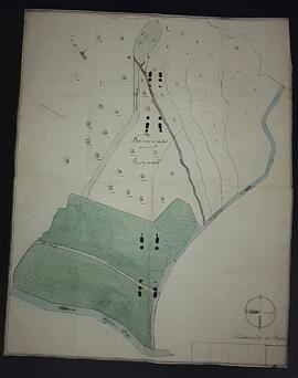
Karte des Bergwalds
Date(s)
- ca. 1850 (Creation)
Level of description
Item
Extent and medium
1 Karte
Name of creator
Repository
Archival history
Scope and content
handkolorierte Karte bez. "Bannwald genannt Bergwald", Bereich zwischen Pleise, Flarschbach und Rosanna; Maßangaben in Zoll/Klafter;
Appraisal, destruction and scheduling
Accruals
System of arrangement
Conditions governing access
Conditions governing reproduction
Language of material
Script of material
Language and script notes
Physical characteristics and technical requirements
Finding aids
Existence and location of originals
Existence and location of copies
Related units of description
Note
in der Mitte durch früheres Einlegen in eine Ringmappe mehrmals gelocht;